
Research & Reports
This is where you will find reports about, and relevant to Residents living in Auckland's City Centre. They may be specifically related to the city centre, or provide support to one of CCRG's policy positions.
CCRG supports efforts to provide meaningful data and insights into our richly diverse residential population.

City Centre Residents’ Survey 2022
This survey updates the last one from 2016.
No great surprises from CCRG about what is likeable, and what is not so much, in the city centre.
They are all matters we and others have been advocating for - so it's always good to see alignment on matters of importance to residents.
Covid has of course, played a big part in the rise of many of the negative perceptions.
A really good response rate, 988 respondents surveyed - thanks so much to all who participated, from CCRG as well as the council, who initiated this 2022 update - this data is really important in supporting initiatives to address issues.
With this data to back them up, CCRG expect our local politicians in collaboration with the Council family, and relevant governmental agencies, to rise to the occasion!
Three actions from this from CCRG which can help with achy things such as safety, noise, being family friendly, climate action, better PT and not needing a car,
Continuing to roll out the CCMP and Access for Eevryone, with identified target dates. This will help to mitigate quite a few of these issues.
Safety - bring back the city centre's public facing Police station. We don't know what more needs to occur here for the police to understand this. Every other centre likelike Akl city centre has a permanent public police presence. It's absurd that NZ police think having a station outside the city centre will do anything to help actual and perceived safety here.
Noise - the noise rules are, as a resident recently said about the recent all-night road works outside their apartment , 'as useful as a chocolate fireguard'. The council rules & enforcement methods are Byzantine and underfunded. And the police are absent in enforcing any of the outrageously noisy vehicles. We need noise & red light cameras rolled out with hefty fines attached to infringements.
CCRG and others had some comments about the survey, in Todd Niall's article Safety dents Auckland city centre dwellers' view of their neighbourhood

Noise measurement chart
The pressure or intensity of sound is commonly expressed in decibels, or dB.
United Nations Environment Programme noise report 2022
Listening to cities - From noisy environments to positive soundscapes
2022 has seen the release of quite a lot of new research about the effects of various pollutants, Noise being one of them.
As cities grow, noise pollution is identified as a top environmental risk. High levels of noise impair human health and well-being – by disrupting sleep or drowning out the beneficial and positive acoustic communications of many animal species that live in these areas. But solutions are at hand, from electrified transport to green spaces – which must all be included in city planning with a view to reducing noise pollution.
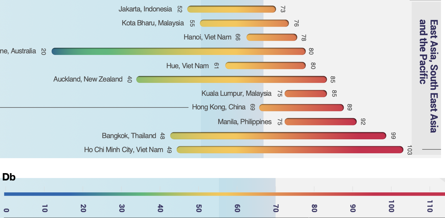
traffic-related noise levels (dB, LAeq) measured for a specific daytime duration in different cities
New Travel routes/options Karanga a Hape Station area
At the December local board meeting, residents from the George Courts Building (on Karangahape Road) presented in public forum about issues they have had around getting their message and views across about the proposed changes to Mercury Lane flowing on from the CRL works.
Read their presentation and see the study and proposals from a September 2022 study that has appeared in the Waitmatā Local Board Minutes attachments from December 2022


Lovely Trees, but Scooters haphazardly parked on footpath, road works signs too (where they can’t even be seen). Footpath clutter. Footpaths colonised by everything not to do with footpaths and walking
What does Access really mean for Disabled people in our transport Network?
We have a ways to go to adapt to the safe and respectful use of new forms of mobility, especially for disabled people (hell we haven't yet managed to sort out cars parked everywhere have we). And it is a valid point especially how our footpaths have been colonised & constrained, mostly due to the demands & hunger of cars. The sooner we address better access for all incl disabled ,with capacity upgrades via street re-allocation, the better.
When we shift from car-compulsory to car-voluntary societies, we transform cities from "disabling" to "enabling" environments., for all, especially for disabled people who have a much wider need and demand and use profile.
This is a very useful summary from a disabled person and respondents, giving some balance to attempts to make spaces more friendly for active transportation and public transit that are then opposed by people saying “what about disabled people?”
Dockline Tram
At CCRG’s Nov 2022 meeting, The Auckland Dockline Trams presented their vision for a re-invigorated tram system between Wynyard and the city centre waterfront.
This idea for ‘A fast, frequent, high-capacity and low-impact transit service between Britomart and the Wynyard Quarter’ was originally promoted in the 2012 Waterfront Plan, but more recently has slipped off the planning radar.
The proposal is for tracks to be extended 600m along the waterfront as far as Quay St. This is a shorter version of what has been proposed in the past – and like then, the most challenging aspect is the need to build a new lifting bridge across the entrance to the Viaduct Harbour.

Carbon benefits of town centre living
A report commissioned by Eke Panuku for their September 2022 board meeting estimating and comparing a standard suburban house annual carbon emissions with housing being developed by Eke Panuku.
Good to get some baseline data.
However the addition of city centre apartment living would have been a useful baseline as well - one of the levers to encourage people to live here.
We suspect that the yearly carbon household emissions might well meet the stated targets - but we don't know what city centre apartment estimates are from this report.
Especially since Transportation is such a big part of emissions.

Albert Park Plans
Albert Park is covered by a Conservation Plan, and a Management Plan that reflects the Conservation Plan.
The Management Plan includes extensive lists and plans of plant and tree types and locations (as of 1997).
Good to see in policy 6.3 (p.43) that there should be a replacement plan for trees!

Trees and Plats Layout - Albert Park Mgmt Plan
Te Komititanga Management Plan
This square is a wonderful addition to our public space realm.
$15 million of city centre targeted rate went towards this project.
Unfortunately, the Management Plan for Te Komititanga, prepared exclusively by AT, is totally transport-focussed rather than Pedestrian-focussed.
This plan had already been adopted and signed off by the Chairperson of Auckland Transports Traffic Control Committee on 13 November 2020.
Why is a public space management plan being signed off by the Auckland Transport Traffic Control Committee?
That is not why we spent $15m developing a Pedestrian Mall.
Looking at the Management Plan, it is 90% about traffic and not how to manage a Civic Plaza.
This movement-focussed outcome is probably not that surprising when a transport entity has prepared the plan, and placemaking is not their role.
Had the local board or other entity whose role was about place making, prepared this it would look very different.
The future of our new Civic Plaza looks more like the past than the future to us.
Of course some vehicle use will always be necessary, but what we want to see is Civic/Pedestrian focussed spaces being used for Civic/Pedestrian-focussed activities.
How a Civic Plaza is managed should never be a traffic control focus – it should always be about people i.e. a Local Board responsibility along with all the other parks and open space facilities we have.
Place over Movement
Noise in the City Centre

CCRG’s June 2022 monthly meeting had speakers from Auckland Council’s Compliance/Noise team on ‘Noise rules and enforcement in the Auckland City Centre’ . What council can and can’t do, how to effectively raise a noise complaint and more.
and Dr James Hamill (UOA Faculty of Medical and Health Sciences) talked about the health impacts of noise, which was quite the eye (and ears) opener!
background info: What Noises Cause Hearing Loss?
aUCKLAND AIR QUALITY REPORTS
It is well established that the Queen street valley has some, if not the worst air quality in NZ. The physical shape of the valley, the high number of diesel buses/vehicles, construction and congested traffic, along with port activities make this almost a certainty.
The July report shows that air quality over the last 6 months has deteriorated:
All the 6 monthly readings for Queen Street indicate declining (worsening) trends.
All but one of the 6 monthly readings for Customs St indicate declining (worsening) trends.

July air quality metrics for Auckland Sites
Fort Street, City Centre Paver replacement policy
We received a response from AT about the Fort St pavers that are in poor shape and unsafe where vehicles cross. The pavers are being removed and are slowly being infilled with asphalt.
This is a city centre targeted rate project so we're always concerned about how poor R&M might degrade the works overtime. We've certainly seen that with furniture being damaged and not replaced, trees inadequately protected and so on.
A Brief history of Auckland’s urban form 1840 - 2018
A fascinating study by Auckland Council’s RIMU (research & evaluation ) team on the changes in Auckland and how these have been influenced. Much information on what we now call the City Centre.
TREES AND VEGETATION: AUCKLAND VEGETATION map
We all know Trees and more greenery are the answer to most things. South Arrow Maps have created this map from Auckland council data sets using LiDAR points classed as medium or high vegetation. The City Centre needs more trees!
High Definition Map HERE
South Arrow Maps - GIS specialists (2019)
construction mitigation - development RESPONSE
With the severe disruption on Albert street caused by the CRL works, there has been discussion on how to mitigate the effects on businesses.
Heart of the City have launched a petition to central government, to urgently provide business disruption support to businesses severely impacted by CRL construction.
You can find the petition and reasons HERE
Here are 3 references on overseas practice, and one has an excellent section on compensation which is more common in the USA than the UK. One takeout mentions that if all good practice is carried out, compensation is not always the best answer.
As often is the case, a big ‘if’.
The People’s Panel - Have your say and help shape Auckland
If you are interested in the future of Auckland, you can join the People's Panel to get involved and have your say by taking part in short surveys sent via email.
Sign up for the People's Panel
Example of some of the Peoples Panel recent surveys
City Centre Urban Form
A fascinating presentation to ACCAB on the rules that drive the City centre Urban form, how the Unitary plan informs this, comparisons to other cities, height & sunlight controls and a lot more. Presented by Auckland Council Plans & places team led by Susan Ensor, Principal Planner.

Report on air quality impacts in Auckland’s City Centre February 2019
A very worrying update on air pollution in the city centre was presented to the City Centre Advisory Board (ACCAB) at its February 2019 meeting.
This report was prepared by Dr. Nick Talbot form Council’s RIMU
Downtown Auckland has the highest air pollution measurements across the Auckland network. And it is getting worse.. Worst is Black Carbon - Resulting in impaired cognitive function and increase the risk of developing dementia and Alzheimer's disease.
Transport is the major contributor - diesel vehicles (trucks), ferries and cruise ships.
A sobering report, albeit with good recommendations and some positive changes on the horizon. But we need to do a lot more if the city centre is to be a healthy place in which to live and work.
Waitematā Local Board Achievements report
1 July 2017 – 30 June 2018
Here is the Board’s annual report of key achievements covering the period 1 July 2017 until 30 June 2018. The Local Board's area stretches from Westmere to Parnell and Newmarket, with residents' City Centre at its heart. Here are a few of the City Centre activities you can read about:
Ellen Melville Centre and Freyberg Place opening
Foreshore heritage signs
Albert Park improvements, Symonds Street cemetery
City Centre Public Amenities Project
Art: Tauranga Waka – the resting place of canoes, Light Weight O at O’Connell Street
Showers for homeless
Tīramarama Way
Road Safety in the City Centre
We all know that the ball has been dropped over the last several years when it comes to safety on our streets . Road safety (or lack thereof) on our city centre streets is in a critical state – every negative statistic has significantly deteriorated. Speeding, red light running, distracted driving, aggression and impatience, often all combined, have led to a totally unacceptable statistic - 84% of city centre deaths & serious injuries involved vulnerable road users - often residents just trying to move about their neighbourhoods.
Auckland Transport presented the grim picture to the City Centre Advisory Board at the September 2018 meeting, whilst committing to reversing this trend with a series of major initiatives.
From AT report to ACCAB (Agenda 18 September 2018)
Noise and Air Pollution in the City Centre
A burning topic (and not just in our lungs) - air quality in the city centre.
The 2014 NIWA/Auckland Council report - Personal Exposure to Noise and Air Pollution in the Queen Street valley (PENAP) – Final Report, and more recently the December 2016 SpaRTANZ Auckland Pilot Study :
“an observationally-based approach to understanding spatial patterns in urban air pollution. By using a dense network of samplers, and analysing specific chemical markers associated with key emission sources, the technique aims to describe the magnitude and spatial extent of the impacts of those sources”.
As of November 2018 NIWA is working with Auckland Council to develop black carbon monitoring network for the city.
NIWA: SpaRTANZ Auckland Pilot Study, December 2016
Policing Levels in the Central Area June 2018
Unfortunately, as of 2020 there is no longer a City Centre Police Station in the City Centre.
Nearest station is:
13-15 College Hill , Freemans Bay
Accessible to the public on the corner of Gudgeon St and Hargreaves Street
NZ POLICE Facebook
Always Dial 111 in an Emergency
Dial 105 to report things that have already happened that don’t need urgent Police assistance - 105 INFO
Police say that Auckland is a safe city by any measure, and that the greatest risks are generally overnight Wednesday through to Sunday morning . Unfortunately incidents of hooliganism, vandalism, destruction, intimidation and degradation of amenity are never captured by the stats. It is also true that a lot of people come into the city centre, and its small area mean such incidents are often easily seen.
Police acknowledge that any safety incident in the city can lead to a perception that the city centre is unsafe. The media is sometimes not helpful in these situations, and it is hard to get the positive messages out.
You can do your bit - contact the Central Police Station for non-emergency matters, or even if you are uncertain who to call - they can assist : 09 302 6400
NIWA Climate Projections Report for Auckland 2017
Auckland Council commissioned NIWA to provide climate change projections including high-resolution maps for Auckland. The implications and impacts of these changes and increasing extreme weather events are alarming, and emphasise the need for concerted and ambitious targets. Especially as more recent studies suggest our previous models and predictions are well on the optimistic side.
SIGNALLING INEQUITY – HOW TRAFFIC SIGNALS DISTRIBUTE TIME TO FAVOUR THE CAR AND DELAY THE PEDESTRIAN
2018-06-12 | DAVID LEVINSON, Transportist
Traffic signals are a source of great inequality in the urban realm, giving priority to motor vehicles over pedestrians. Cities and states say they want to encourage walking and biking for many reasons: it is space efficient, it has less environmental impact, it is healthier, it is safer for other travelers, and, since, it reduces the numbers of cars on the road, even motorists should be in favour of other people walking. To help achieve that, road management agencies should take the lead in reprioritising traffic signals by redistributing intersection delay from pedestrians to cars.
Presented to the City Centre Advisory Board 23 May 2018
The Auckland City Centre Public Art Plan was presented in May.
Its purpose is to guide the strategic and transformative investment of the city centre targeted rate funds into public art, supported as well by regional and other art funding sources. The City Centre Advisory Board endorsed the plan as one of the delivery documents for the City Centre Master Plan and the Waterfront Plan, agreed upon in the investment priorities outlined for the City Centre Targeted Rate, and supported the annual reporting framework.
Auckland Parking Strategy May 2015
Auckland Transport's parking strategy sets out the approach to the management of car parking in Auckland (both on- and off-street), and explains how parking management can deliver on wider transport objectives. It was crerate following extensive consult in 2014. Some of the aims are:
Prioritise the safe and efficient movement of people, services and goods on the road network.
Support place-making, amenity and good urban design outcomes.
Support the economic development of the Auckland City Centre, metropolitan and town centres.
Waterfront Briefing - CITY CENTRE & WATERFRONT PRESENTATION 19.12.17
Presented by Auckland Council and Panuku, a comprehensive update on plans for Downtown & Waterfront - Midtown - Central Wharves - Wynyard Quarter and America’s Cup. The big picture and how the various elements tie together - hopefully.
The Waitematā Local Board Plan 2017 & achievements 2016-17 report
Past & Future
This is the 2017-20 plan, that supports the 30 year Auckland Plan, at the local level. The local board plan takes into account the outcomes in the 30-year Auckland Plan to help deliver this vision. There are 6 Outcomes to make Waitematā a better place - it's all about People.
The Local Board's area stretches from Westmere to Parnell and Newmarket, with residents' City Centre at its heart.
Its offices are at 52 Swanson St, City Centre
APRIL 2018 COUNCIL UPDATE ON BUILDING INSPECTIONS

Presentation from the Auckland Council Building Control Talk presentation April 2018
Over 800 new residents each week, 2,000 building consents of which 97% require more information and are put on hold, 160,000 inspections of which 25% fail
The pressure is constantly on council to efficiently process building consents in a timely manner, even more so now with the housing crisis we have. Howeve, Council is inevitably the first in the firing line when things go wrong - weathertightness, ACP, & building WOF issues spring to mind.
This overview summarises the stats, and issues across Auckland.
George Weeks - Specialist Urban Design, Auckland Council
2 Part slideshow highlighting updates and current thinking around several waterfront projects and how they relate to the and its goals - especially and walkability and public realm improvements. Also facts and figures around population growth, Lower Queen Street, CRL and public transportation improvements.
Waterfront Briefing - AMERICA'S CUP 36 PRESENTATION 19.12.17

Rod Marler - Director Design & Place, Panuku
CCRG attended this Stakeholder's meeting. Some comments:
What happens after the AC36 event? Additional public access around the wharves is crucial, future of the base buildings, view shafts, future events. Guarantees the bulky sheds will be removed?
There is interest in public access to the AC36 village during the event, locations for viewing the races, logistics of the event, servicing and access for existing businesses.
Questions about existing bulk liquids tanks, hazardous zones.
Questions about design and scale of base buildings; views from Eastern Viaduct
City Centre Summary Sheets October 2017
Auckland City Centre Summary Sheets, Auckland Council/Auckland Design Office Oct 2017
Auckland Council Planning Committee asked for ways to tell the city centre story in a way that will resonate. The Auckland Design Office have produced a series of summary sheets that describe the main points in a clear and accessible style:
Sheet 1: Heart of Auckland: The city centre and its relevance to the entire region
Sheet 2: Urban Design + Transport Design: The importance of walking as a transport mode
Sheet 3: Living in the City Centre: The growth of central Auckland as a place to live
Sheet 4: Connectivity Creates Wealth: The financial and economic benefits of a strong city centre
Sheet 5: Targeting Better Streets: The importance of the City Centre Targeted Rate (CCTR)
Sheet 6: So Why Invest Now? Delivering movement and place simultaneously
Perceptions of Living in the Inner City:
Survey of Auckland inner city residents 2016
This report (commissioned by Auckland Council), presents the results of a 2016 survey which explored residents’ levels of satisfaction with various aspects of living in the inner city, and provides an update on results from a previous baseline survey undertaken in 2013, (found below).
Auckalnd Council
Business Case for Walking - Investigating the Economic Value of Walking in the Auckland City Centre
Valuing the public realm and providing insights into the many social, practical, transport and and economic benefits of walking, and prioiritsing walking in the city centre.
Measuring the 'cost' of pedestrian delay and congestion to the city. Along with the obvious links between walkability and economic success and social benefit.
Fascinating report adding a sound business perspective, to what we all knew already is best for the city.
Infometrics
City Centre Annual Economic Profile 2016
Detailed and fascinating info on the economic and population profile of the City Centre.
Geography economy employment productivity
population businesses. For example:
The City Centre population was 39,860 in 2016, up 14% from a year earlier. New Zealand's total population grew by 2.1% over the same period.
Population growth in the City Centre averaged 8.7%pa over the last 5 years compared with 1.4%pa in New Zealand.
Since 2006 growth in the City Centre reached a high of 15.6%pa in 2015 and a low of 1.1%pa in 2012.
Map of all Site Locations assessed (by group)
Bonus floor provisions and Auckland City Centre's 60 + Public Spaces - Some Known, Others Hidden - Report
The City Centre has over 60 public access routes through, around, or via private buildings.
Bonus floor provisions allowed developers to increase the floor space of a development, by providing public access or benefit from the change. These usually take the form of pedestrian access ways through buildings, widened footpaths, public viewing decks, plazas, and privately-owned art works.
Council is responsible for monitoring the consent conditions that result in bonus floor provisions and for working with building owners or managers to ensure that public access remains as agreed over time.
Splice commissioned Akl Uni Master Urban Planning students to research and evaluate if all these spaces are still conforming to their resource consents. Not all were, and The Waitematā Local Board is now following up to ensure that these agreed concessions are maintained for the public. These two reports are below.

image: CRL
Lower Albert Street Public Realm
May 2017
New Plans for Albert Street Improvements post-CRL. The AKL City Centre Advisory Board (ACCAB) has endorsed just under $20m of city centre targeted rate to create a better streetscape, once the CRL works are done.
CCRG has 2 seats on ACCAB, & one of our group joined with Heart of the City , the City Rail Link team and Auckland Council's Design Office, for the last 6 months to look at ways in which the Board could contribute to making Albert Street an even better Urban Space. Not an easy task when you consider all the various demands being made on this street.
Have a look at the concepts , considerations, as well as some financials, that have led this design process and the proposed results.
Click Learn More for the full presentation to the Board.
2013
Inner City Residents' Survey Research report 2013
This Waitematā Local Board-sponsored report on the 2013 survey of inner city residents, emerged out of the Local Board's desire to understand residents' concerns around specific issues.
It identified a number of key themes which highlight the positives of inner city living, as well as several areas which were highlighted as requiring improvement, for example the level of noise on the street, both during the day and at night. Safety and security were also key concerns with residents wanting higher levels of police presence.
Te Rerenga-ora-iti/Emily Place Signage
This is an example of one of many dedicated Māori signs that are telling the story of mana whenua’s connection to, and history of the region. This particular spot is very rich in heritage.
On September 18, 1840 a signing ceremony was held here where 3000 acres of land was gifted to facilitate the creation Auckland. Te Kawau, Te Reweti and Te Horo signed the deed on behalf of their people. This was once a headland that stretched from Princes street above and out to Quay Street, and known as Point Britomart to settlers, but was quarried away and used to reclaim the surrounding bays - particularly Commercial Bay.
City Centre Masterplan 2012 - Auckland Council
The Auckland city centre masterplan is a 20-year vision that sets the direction for the future of the city centre. One of the two two initial areas of focus for development is the city centre. This is an award-winning document that provides a vision, and concrete steps about how to implement that vision. It is currently undergoing a review or 'refresh'. CCRG is a strong supporter of this plan, and the transformational projects that are making the city centre a much better place for residents.
The Text-only version is HERE. Click Learn More for the full bells and whistle colour report.
Experiences of parents living in inner city Auckland
This 2015/16 co-design project prepared by Plunket, examines many of the issues and difficulties families living in Auckland's city centre may have in relation to the wellness and care of their family. Issues such as immigration, housing, finances, personal relationships, transport, and study, can all add to an already demanding situation. This project aims to help everyone better understand the positive and/or negative experiences of raising children (under 5’s) in Auckland city centre.

Darren Davis on Road Safety and Pork Chops - Auckland Design Manual, May 2017
Design for Auckland
In honor of Road Safety Week Aotearoa, Darren Davis, part of the Auckland Council’s City Centre Design Team speaks about the state of road safety in Auckland.
While there are ongoing improvements to the pedestrian and cycling experience, there is much yet to do, to undo the last 60+ years of street design that has prioritised fast moving traffic.
30 kph speed limits, a change to pedestrian priority laws, and getting rid of 'pork chop Islands - just some of the proposals also supported by CCRG.
Creating walking cities: a blueprint for change- Living Streets
A legacy of designing our towns and cities around
cars rather than people, has left us less healthy,
our roads more congested, and our cities less
well-off. This Living Streets UK report presents a different vision for cities which aims to create walking cities – safe and inviting to people of all ages, where everyone can walk safely, and communities have quality spaces to thrive. Walking cities mean better cities for everyone.
The Relationship between Pedestrian
Connectivity and Economic Productivity
in Auckland’s City Centre - March 2017
We all know that pedestrian activity is fantastic for a vibrant city and great for businesses too. This Auckland Council project, seeks to understand the value of walking (pedestrian connectivity) to the Auckland city centre’s economy. Walkability is also the central factor in six of the eight transformational shifts in the Auckland City Centre Masterplan. Understanding the connectivity of firms through pedestrian networks and the value to the Auckland city centre’s economy will help decision-makers to understand both the costs of disruptions to walkability and the benefits of improved walking conditions.

"Experience and expression of social isolation by inner-city high-rise residents", Love M. Chile Xavier M. Black Carol Neill, Housing, Care and Support (2014)
"The purpose of this paper is to examine the significance of social isolation and the factors that create social isolation for residents of inner-city high-rise apartment communities. We critically examine how the physical environment and perceptions of safety in apartment buildings and the inner-city implicate the quality of interactions between residents and with their neighbourhood community."
Waitematā Local Board Achievements Report 1 July 2015 - 30 June 2016
Local boards are a unique and vital element of Auckland Council’s governance. Driven by a great understanding of their communities, the Waitematā Local Board members have worked together to achieve progress in areas of priority determined by the community through the Local Board Plan 2014. Here is the previous board's report to 30 June 2016.
Cruise Action Plan for Auckland May 2015
Auckland Tourism, Events and Economic Development (ATEED) is a council-controlled organisation (CCO) established to lift
Auckland’s economic well-being and enhance the region’s performance as the growth engine of New Zealand's economy.
Becoming a Low Carbon Community An Action Plan -2015
The Waitematā Local Board was the first to develop their own plan.
"This low carbon action plan is a positive step towards Auckland’s transformation into an energy-resilient low carbon city."
There are many challenges - rapid growth pressures, ageing infrastructure, pollution from vehicles, and diesel trucks, buses, the port. Not to mention the pressures to consume more and more.
This plan brings together a range of possible actions to adopt carbon practices and reduce carbon emissions within the community, businesses infrastructure, transport and housing.
Stakeholders' Workshop Dec 2017
Results of the Stakeholders' Workshop Dec 2017
Auckland Council
Residents joined with other city centre groups to discuss, a vision for the city centre's new community facility - one with residents at its heart. Follow the very visual process and the many desired outcomes that were propsed.
from ACCAB Agenda March 2017
Business case for Monitoring Pedestrian Impact on the City Centre SMART CITIES March 2017

Listen Up